Navigazione Toggle
Ricerca
India
dettagli del
paese
Afghanistan
Albania
Algeria
Andorra
Angola
Anguilla
Antigua e Barbuda
Antille Olandesi
Arabia Saudita
Argentina
Armenia
Aruba
Australia
Austria
Azerbaijan
Bahamas,
Bahrain
Bangladesh
Barbados
Belgio
Belize
Benin
Bermuda
Bhutan
Bielorussia
Bolivia
Bosnia Erzegovina
Botswana
Brasile
Brunei
Bulgaria
Burkina Faso
Burundi
Cambogia
Camerun
Canada
Capo Verde
Ciad
Cile
Cina
Cipro
Cocos (Keeling)
Colombia
Comore
Corea del Nord
Corea del Sud
Costa D'avorio
Costa Rica
Croazia
Cuba
Danimarca
Dominica
Ecuador
Egitto
El Salvador
Emirati Arabi Uniti
Eritrea
Estonia
Etiopia
Falkland, Isole (Isole Malvinas)
Fiji
Filippine
Finlandia
Francia
Gabon
Gambia, The
Georgia
Germania
Ghana
Giamaica
Giappone
Gibilterra
Gibuti
Giordania
Grecia
Grenada
Groenlandia
Guadalupa
Guam
Guatemala
Guernsey
Guinea
Guinea Equatoriale
Guinea-Bissau
Guyana
Haiti
Honduras
Hong Kong
India
Indonesia
Iran
Iraq
Irlanda
Islanda
Isola di natale
Isola Norfolk
Isole Cayman
Isole Cook
Isole Faroe
Isole Marianne Settentrionali
Isole Marshall
Isole Salomone
Isole Turks e Caicos
Isole Vergini (USA)
Israele
Italia
Jersey
Kazakistan
Kenya
Kirghizistan
Kiribati
Kuwait
Laos
Lesotho
Lettonia
Libano
Liberia
Libia
Liechtenstein
Lituania
Lussemburgo
Macao
Macedonia, ex Repubblica iugoslava di
Madagascar
Malawi
Maldive
Malesia
Mali
Malta
Marocco
Martinica
Mauritania
Mauritius
Mayotte
Messico
Micronesia, Stati federati
Moldavia
Monaco
Mongolia
Montenegro
Montserrat
Mozambico
Myanmar
Namibia
Nauru
Nepal
Nicaragua
Niger
Nigeria
Niue
Norvegia
Nuova Caledonia
Nuova Zelanda
Oman
Paesi Bassi
Pakistan
Palau
Panama
Papua Nuova Guinea
Paraguay
Peru
Pitcairn, Isole
Polinesia Francese
Polinesia Francese
Polonia
Portogallo
Portorico
Qatar
Regno Unito
Repubblica Ceca
Repubblica Centrafricana
Repubblica del Congo
Repubblica Democratica del Congo
Repubblica Dominicana
Reunion
Romania
Ruanda
Russia
Sahara Occidentale
Saint Kitts e Nevis
Saint Lucia
Saint Pierre e Miquelon
Saint Vincent e Grenadine
Samoa
Samoa Americana
San Marino
Sant'Elena
Senegal
Serbia
Seychelles
Sierra Leone
Singapore
Siria
Slovacchia
Slovenia
Somalia
Spagna
Sri Lanka
Stati Uniti (USA)
Sud Africa
Sudan
Suriname
Svalbard
Svezia
Svizzera
Swaziland
São Tomé e Príncipe
Tagikistan
Tailandia
Taiwan
Tanzania
Timor Est
Togo
Tokelau
Tonga
Trinidad e Tobago
Tunisia
Turchia
Turkmenistan
Tuvalu
Ucraina
Uganda
Ungheria
Uruguay
Uzbekistan
Vanuatu
Venezuela
Vietnam
Wallis e Futuna
Yemen
Zambia
Zimbabwe
Nuova Delhi
dettagli della
città
Agra
Ahmedabad
Amritsar
Bangalore
Bhopal
Bhubaneswar
Bombay
Calcutta
Chennai
Goa
Hyderabad
Indore
Jaipur
Jodhpur
Kalyan
Kanpur
Lucknow
Madurai
Moradabad
Nainital
Nuova Delhi
Pune
Thiruvananthapuram (Trivandrum)
Udaipur
Visakhapatnam
Annuncio gratuito
Contatti
Serchhip Helipad
India
List of airports India
Serchhip Helipad
Informazioni sull'aeroporto - Serchhip Helipad, India
Descrizione
Valore
IATA
(Codice aeroporto International Air Transport Association)
Nessun codice IATA
Tipo
Eliporto
Codice aeroporto locale
-
Codice aeroporto GPS
Longitudine
23.32875
Latitudine
92.8560666667
Immagini vicino Serchhip Helipad, India
Immagini di Serchhip Helipad
Materiale informativo - Nuova Delhi
Prezzi, costo della vita Nuova Delhi
Time Nuova Delhi
Fuso orario - Nuova Delhi, India
Tempo - Nuova Delhi, India
Mappa di Nuova Delhi
Bandiera nazionale India
Nuova Delhi - telefono cellulare il codice, come chiamare Nuova Delhi
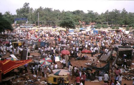
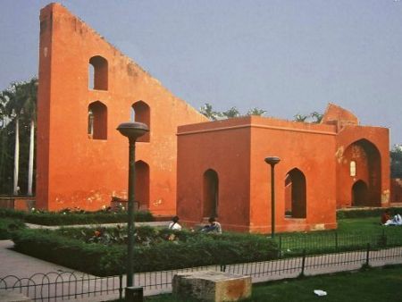
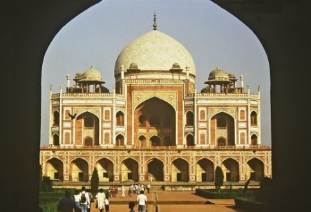
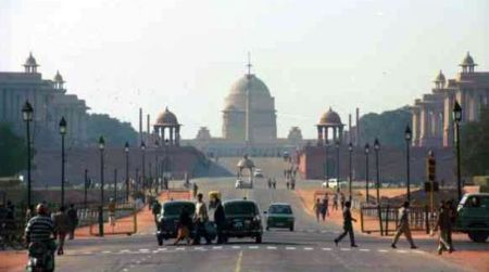
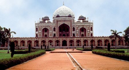
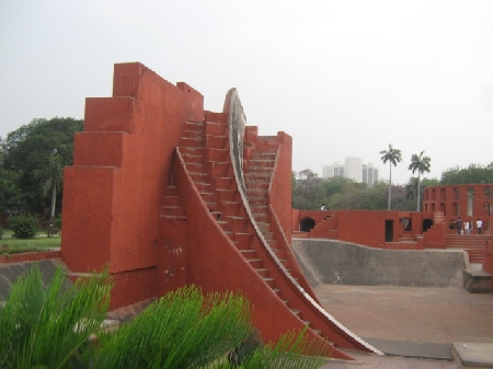
Immagini di Nuova Delhi
Distanze da Nuova Delhi, India
Materiale informativo - India
Valuta India, Rupia indiana
Calcolatore di valuta Rupia indiana
Ambasciate India
Mappa di India
Lista degli aeroporti India
Note del viaggiatore
Scopri Macchia di Martignano: un gioiello naturale tra lago, boschi e avventura
Fonte del Turano: Il gioiello nascosto nel cuore del Lazio – cosa vedere, cosa fare, dove andare e perché amerai questo luogo unico
Parco del Sorbo: la valle incantata che devi assolutamente visitare vicino a Roma
Tor Paterno: Scopri il Paradiso Sottomarino del Lazio a Due Passi da Roma
Incredibile Faro delle Formiche di Grosseto: un’esperienza unica tra natura selvaggia, storia e mare aperto
Invia un racconto di viaggio
Galleria fotografica
India, Nuova Delhi
Aggiungi le tue foto
Immagini di Nuova Delhi »